Dutch John Resort
About Us
All About Dutch John, Flaming Gorge & the Green River
Where or who is Dutch John?
The Story
How did Dutch John get its name?
The area of Dutch John, Utah is not an incorporated town, but is maintained and managed by Daggett County. The housing in the area was originally constructed by the Bureau of Reclamation to house those who were working on the Flaming Gorge Dam.
The area received its name from John Honselena, often mispronounced “Hunslinger”, who was actually a native of Sheiswig, Germany. He raised horses and had a summer camp and cabin near the Summit Springs Guard Station. He used winter range on the east side of the Green River in what was known as “Joe’s Pasture”. His headquarters was along the river in Red Canyon and his range spilled over into the area now called Dutch John Flat or Dutch John Bench.
Honselena was given the name “Dutch John” because he talked with a German accent and was a little hard to understand. To the people of the time, he sounded like a “Dutchman”. He seems to have just faded away.
What Makes Dutch John, Dutch John?
What are the characteristics that make Dutch John?
- A unique mountain community cherished for its natural and scenic beauty.
- Access to world class fishing, wildlife viewing and hunting.
- A small community quality of life.
- “City Like” but in the country.
More Dutch John Information
The community of Dutch John, Utah, is not an incorporated town.
Services are administered or provided by Daggett County.
The community is located at 6324 feet above sea level and has a population that varies from nearly 250 in the summer to about 150 during the winter months. The Flaming Gorge Dam is only 3 miles from Dutch John. The Bureau of Reclamation offers guided tours of the Dam and powerplant during the summertime.
The Visitors Center is open year round. Other nearby places to visit include the US Forest Service Visitor’s Center at Red Canyon, the Swett Ranch, Ute Tower Lookout, the Cedar Springs Marina and a little farther away is the Jarvie Ranch in Brown’s Park. Dutch John has an airport with a paved landing strip, 6000 feet in length.
Dutch John Resort Google Location
Contact Information
Dutch John Resort
Address
1050 South Blvd. Dutch John, Utah 84023
frontdesk@dutchjohnresort.com
Phone
(435) 848-8000
About Flaming Gorge &
The Green River
Flaming Gorge Reservoir
Flaming Gorge Reservoir is the largest reservoir in Wyoming, on the Green River, impounded behind the Flaming Gorge Dam. Construction on the dam began in 1958 and was completed in 1964. The reservoir stores 3,788,900 acre-feet (4.6735×10⁹ m3) of water when measured at an elevation of 6,040 feet (1,841 m) above sea-level (maximum).

Location
The reservoir is mainly in southwest Wyoming and partially in northeastern Utah. The northern tip of the reservoir is 10 miles (16 km) southeast of Green River, Wyoming, 14 mi (23 km) southwest of Rock Springs, Wyoming, and the Southern tip is approximately 40 miles (64 km) north of Vernal, Utah. The lake straddles the Utah-Wyoming border. The nearby town of Dutch John, Utah, was built to serve as a base camp during construction of the dam, and as an administrative site afterwards.[
Geology
The foundation of the reservoir is a steep-sided narrow canyon composed of siliceous sandstone and hard quartzites inter-bedded with softer shales, siltstones, and argillites. About 1.5 miles (2.4 km) east of the dam, a road cut has revealed a fault scarp on the southbound side with about 9 feet (3 m) of slippage.
Recreation
Visitors enjoy hiking, boating, fishing, windsurfing, camping, backpacking, cross-country skiing, and snowmobiling within Flaming Gorge National Recreation Area, which is operated by Ashley National Forest. Camp sites can be found close to the dam and along Highway 191 for a fee, as well as free throughout the area. Campgrounds operated by the U.S. Forest Service close in the winter months, with the exception of Dripping Springs near Dutch John. There are also public camp sites at Buck Board and Lucerne Marinas, along Highway 530 on the west side of the reservoir. The many available fish species in the reservoir and surrounding lakes are Colorado River Cutthroat trout, Brown trout, Rainbow trout, Lake trout, Kokanee salmon, Smallmouth bass, Burbot and Common carp. The Green River is a popular spot for fishing, mainly below the dam. The river’s ice cold water and beautiful structure make it a world class, world-renowned fly fishing stream.
History and Location
Contrary to its namesake, Flaming Gorge, the dam actually lies in steep, rapid-strewn Red Canyon in northeastern Utah, close to where the Green River cuts through the Uinta Mountains. The canyon, for which the dam is named, is buried under the reservoir almost 20 miles (32 km) upstream.[4] Red Canyon is the narrowest and deepest of the four on the Green in the area (Horseshoe, Kingfisher, Red and Flaming Gorge), which made it the best site for the building of a dam. Flaming Gorge, on the other hand, was named by John Wesley Powell on his 1869 expedition down the Green and Colorado rivers for the “brilliant, flaming red of its rocks [when the sun shone upon them].”[5]
Flaming Gorge Dam is one of six that make up the Colorado River Storage Project (CRSP), a massive system of reservoirs created in the upper Colorado River Basin by the Bureau of Reclamation from the 1950s to the 1970s.[6] The project itself was the indirect result of a system of agreements signed by the seven U.S. states and two Mexican provinces in the early 20th century dividing the flow of the Colorado River among them. Among the terms stated in the 1922 Colorado River Compact reserved 7.5 million acre-feet (9.3 km3) for the Upper Basin states of Wyoming, Colorado, Utah and New Mexico and an equal amount for the Lower Basin states of Arizona, Nevada and California.[7] Due to the Colorado’s high year-to-year variations in flow, the upper basin could not fulfill the lower basin’s allotments in dry years, and much water was wasted during wet years because of the lack of a means to impound it.[6]
Well before the CRSP’s inception in 1956, the Bureau had begun to look for suitable reservoir sites along the upper Colorado and tributaries such as the Green, San Juan and Gunnison Rivers. One of the earlier proposals was called Echo Park Dam, at the confluence of the Green and Yampa Rivers within the Dinosaur National Monument in northwestern Colorado. The Sierra Club, led by David Brower, rallied against the proposal in the media and later in the courts.[8]: 171–174 When the Bureau backed down from the Echo Park proposal, it was seen as one of the environmentalism movement’s early victories – but it came with a compromise. A dam would still be built on the Green River, just 50 miles (80 km) upstream near a brilliant red-rock canyon called Flaming Gorge.[9] A common misconception is that the building of the controversial Glen Canyon Dam was part of this “compromise for Echo Park”, but in reality the Bureau had always planned to build a dam at Glen Canyon regardless of the outcome of the Echo Park debate.[10]
Apart from impounding the Green River, Flaming Gorge Dam also carries U.S. Route 191 over the river.
Flaming Gorge Dam
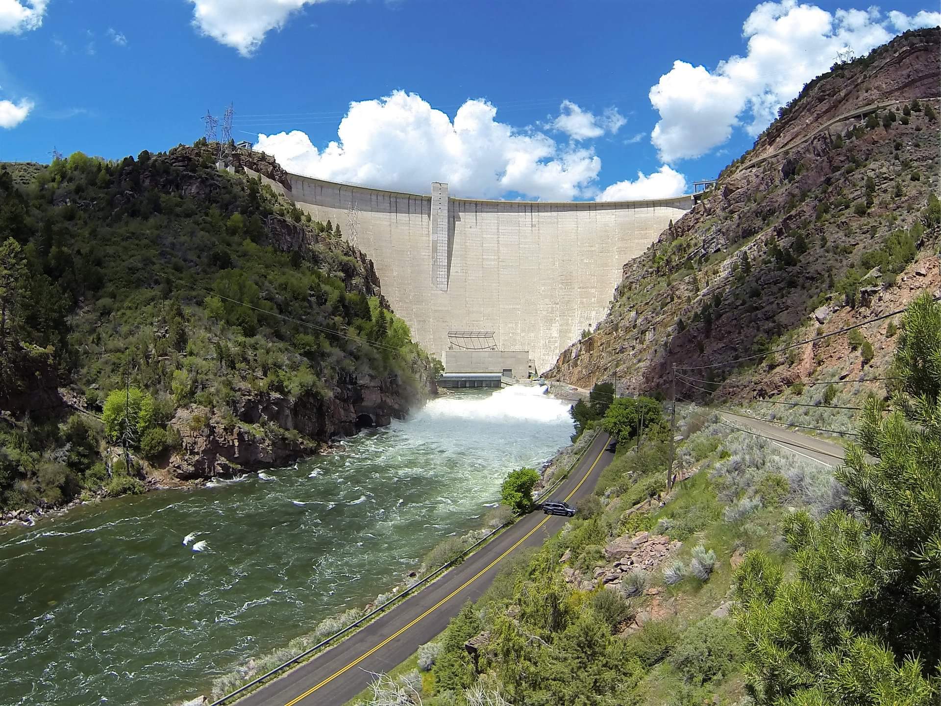
Flaming Gorge Dam is a concrete thin-arch dam on the Green River, a major tributary of the Colorado River, in northern Utah in the United States. Flaming Gorge Dam forms the Flaming Gorge Reservoir, which extends 91 miles (146 km) into southern Wyoming, submerging four distinct gorges of the Green River. The dam is a major component of the Colorado River Storage Project, which stores and distributes upper Colorado River Basin water.
The dam takes its name from a nearby section of the Green River canyon, named by John Wesley Powell in 1869. It was built by the U.S. Bureau of Reclamation between 1958 and 1964. The dam is 502 feet (153 m) high and 1,285 feet (392 m) long, and its reservoir has a capacity of more than 3.7 million acre-feet (4.6 km3), or about twice the annual flow of the upper Green. Operated to provide long-term storage for downstream water-rights commitments, the dam is also a major source of hydroelectricity and is the main flood-control facility for the Green River system.
The dam and reservoir have fragmented the upper Green River, blocking fish migration and significantly impacting many native species. Water released from the dam is generally cold and clear, as compared to the river’s naturally warm and silty flow, further changing the local riverine ecology. However, the cold water from Flaming Gorge has transformed about 28 miles (45 km) of the Green into a “Blue Ribbon Trout Fishery”.[citation needed] The Flaming Gorge Reservoir, largely situated in Flaming Gorge National Recreation Area, is also considered one of Utah and Wyoming’s greatest fisheries.

